Please forgive the awkward composition where the pictures have been pasted in. I cut and pasted this from my weight loss site, where I composed it first. I'm too tired from the hike to figure out how to fix this one...
Yesterday, Budd came home with the news that a couple of the ladies who work at the visitor center were going to do the first part of the hike, then go back UP Bare Trail while the others went on. The only catch was that I would have to be at the visitor center at 6:45 a.m. to join them. I'll admit I wavered. This was still going to be a very strenuous hike, and I wasn't sure I was up to it. But with the thought that I would hate myself if I passed on this opportunity, I prepared for it before going to bed at a suitably early hour...just before 11 p.m.
5:30 a.m. found me awake and anxious. Could I make it? Should I even try? What if I held the others up, or worse yet, someone had to accompany me out before we reached the bottom? Let me stress that this is a trail only in the sense that the locals know where to climb down and up, and that there are a few steps or hand-and-toe holds carved into the rocks at intervals along the way. This was going to be a climb! But in the end the knowledge of the pain of regret got me out of bed and through breakfast, in time to be first at the visitor center, waiting for the others to arrive.
Our guide was the last to arrive, about half an hour late, so it was not until 7:30 a.m. that we arrived at the 'trail head', parked the vehicles, and set off. From the top, I tried to take a picture down into the canyon where we would be going, but the sun was in an awkward position, so it's hard to see the result.

The wavy layers of sedimentary rock at the bottom of the picture were sloped enough that my feet pointed down as if I were on tiptoe as we took this part of the 'trail' down to the edge where the bright rock ends here. From this point over to the south, I didn't have time to take pictures, as the rest of the party was setting quite a pace, and I was picking my way along an edge that seemed no wider than my shoes, some yards behind them, and leaning into the uphill side of the rock with all my focus on not looking down.
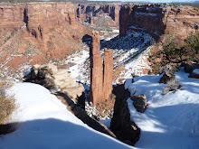
Until we arrived here.
Until we arrived here.
Yes, we were going over the rim here, and it was only wide enough for one, so I was able to get a vista shot as the others descended. In the distance, to the left of what may be too small to recognize as a cornfield, and directly below the tallest cliff on the other side, is the round dome rock where Budd and I were standing in the picture I posted a couple of weeks ago. And yes, we're going down there. However, I have performed a little trick of the eye with the camera. Below the rim in the foreground is a V-shaped drainage chute, with steps carved either by Navajos or wind and water, so that it was actually a very easy descent. The others made it like a staircase...I scooted down using my butt, hands and feet.
After a rather hair-raising descent down hand-and-toe steps that had to be negotiated by dropping over a rim and turning around with my face to the wall, we arrived at the slide, where the rest of the party stopped to hear the guide explain that this one, which was about 14 feet long and had only a slight slope (look at the feet in the picture for an idea) was where younger children play when their chores are done.
He then described a longer one, about 70 feet and ending in a sheer cliff, where the teenagers play. I thought it best not to ask the question on the tip of my tongue...how many do they lose each year...as the farm below belonged to the guide's family, and I'm sure it was his young nieces and nephews who were doing the sliding. I used the time to catch up to the others and take a couple of pictures. From here I knew I could do it, because this is where we were on Sunday, the 19th.
I also took the opportunity to get a better shot of the stairs carved into the opposite cliff wall (the wavy line to the left of the cave). Thank goodness we weren't going up those!
Once at the bottom, we decided to go about 1/2 mile up the wash with the rest of the party before they turned around, and shortly arrived at Ledge Ruin where we stopped for a while before heading out, leaving the main party to go on another 1 1/2 miles before ascending on the south side. On the way back, I took advantage of a clearing to get a shot of where we came from. Although he is too far away to see, the ranger who shuttled most of us to the trail head is at the top, and turned out to be invaluable in getting us back up there, as the trail is unmarked most of the way. No, you can't see the way we came down from this shot, but the top is where we walked along until we got to the chute where I had to scoot down on five-point contact.
And here is the moment of truth. I will finally be brave enough to post a picture of me from the back, as I handed Nora the camera to record for posterity my posterior climbing back up the hand-and-toe ladder that had given me pause coming down.
MUCH easier to go back up, although I have to say my heart was at times beating so hard I could hear it echoing off the canyon walls. But with stops to get my breath, and Fernando to scout the way, we made it. We were about halfway up at this point, and I didn't take many pictures after this.
Along the way I slipped and started to lose my balance, so to avoid taking a nasty tumble of about 6 feet, I put my hand down, unfortunately neglecting to look where I was putting it. I got a number of tiny sticker spines in my right hand for my trouble, and was a little handicapped when the climb up required a scramble on hands and feet, so picture-taking was the last thing on my mind. The things on my mind were, in order:
1) Are we there yet?
2) I REALLY could use a restroom about now
3) I can't believe I did this!
We arrived back at the top at 11:30 a.m., 4 hours almost to the minute from when we had set out. Give me a week to recover, and I want to do it again!
PS As I write this, a violent wind and sand storm has blown up with accompanying rain clouds. Thank goodness the others expected to be back to the top of South Rim about an hour and a half ago!
After a rather hair-raising descent down hand-and-toe steps that had to be negotiated by dropping over a rim and turning around with my face to the wall, we arrived at the slide, where the rest of the party stopped to hear the guide explain that this one, which was about 14 feet long and had only a slight slope (look at the feet in the picture for an idea) was where younger children play when their chores are done.
He then described a longer one, about 70 feet and ending in a sheer cliff, where the teenagers play. I thought it best not to ask the question on the tip of my tongue...how many do they lose each year...as the farm below belonged to the guide's family, and I'm sure it was his young nieces and nephews who were doing the sliding. I used the time to catch up to the others and take a couple of pictures. From here I knew I could do it, because this is where we were on Sunday, the 19th.
I also took the opportunity to get a better shot of the stairs carved into the
opposite cliff wall (the wavy line to the left of the cave). Thank goodness we weren't going up those!Once at the bottom, we decided to go about 1/2 mile up the wash with the rest of the party before they turned around, and shortly arrived at Ledge Ruin where we stopped for a while before heading out, leaving the main party to go on another 1 1/2 miles before ascending on the south side. On the way back, I took advantage of a clearing to get a shot of where we came from.
Although he is too far away to see, the ranger who shuttled most of us to the trail head is at the top, and turned out to be invaluable in getting us back up there, as the trail is unmarked most of the way. No, you can't see the way we came down from this shot, but the top is where we walked along until we got to the chute where I had to scoot down on five-point contact.And here is the moment of truth. I will finally be brave enough to post a picture of me from the back, as I handed Nora the camera to record for posterity my posterior climbing back up the hand-and-toe ladder that had given me pause coming down.
MUCH easier to go back up, although I have to say my heart was at times beating so hard I could hear it echoing off the canyon walls. But with stops to get my breath, and Fernando to scout the way, we made it. We were about halfway up at this point, and I didn't take many pictures after this.
Along the way I slipped and started to lose my balance, so to avoid taking a nasty tumble of about 6 feet, I put my hand down, unfortunately neglecting to look where I was putting it. I got a number of tiny sticker spines in my right hand for my trouble, and was a little handicapped when the climb up required a scramble on hands and feet, so picture-taking was the last thing on my mind. The things on my mind were, in order:
1) Are we there yet?
2) I REALLY could use a restroom about now
3) I can't believe I did this!
We arrived back at the top at 11:30 a.m., 4 hours almost to the minute from when we had set out. Give me a week to recover, and I want to do it again!
PS As I write this, a violent wind and sand storm has blown up with accompanying rain clouds. Thank goodness the others expected to be back to the top of South Rim about an hour and a half ago!
No comments:
Post a Comment