My destination, for the first time, was not the end of the trail. I had decided to tackle a 'strenuous' trail, which in this case means steep. The end summits Guadalupe Peak at 8751 ft. according to the latest calculations. Not only had I started out too late in the day, but I was by no means certain I was up to the 8.4 mile round trip. The last hike, at 6.8, was very tiring, and it was basically flat. So today, my intention was to go as high as I could before my legs turned to jelly, then turn around and come back.
Since I didn't know how far that would be, I decided to take Bigmouth (our GPS, who is female) along. She has a usage mode for walking as well as driving (also bicycling and scootering, whatever that is--why would a scooter be different from a bike?), but we haven't used it much, so I wasn't certain what I was doing. I started by saving my location at the campground/trailhead parking lot, and taking mental note of the elevation (which I promptly forgot). The internet tells me it's 5633 feet. Then, leaving her on, I put her in my backpack. She is a car model, not suitable for carrying, and I didn't have a pocket. Fortunately, she did track me as I walked.
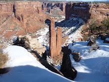
The trail from Pine Springs campground divides several times, the first time within sight of the trailhead. From this division, you can take Devil's Hall trail, which branches off to Tejas trail a little further along. You can take El Capitan trail, leading back to the east and south around the famous formation and back in a loop. Or you can take Guadalupe, which clearly states no horses on this trail. I set off in the direction of the arrow, and no more than five minutes later ran into this bloke and had to step off the trail to leave room for his horses. Where the heck had he come from?

As I pondered that question, I began to believe that there was another branch of the trail ahead, right to Devil's Hall and left to Guadalupe Peak and El Capitan. I should never trust the map that's in my head, although it's pretty good most of the time. Sometimes the gremlins in there turn it around. But I could hear voices from up ahead, so I knew I wasn't alone on the trail, a comforting thought as I'm always aware that I could require rescue even for a relatively minor injury.
Soon I began to realize that I wasn't recognizing this trail, which I thought I should, still believing it hadn't divided yet. I had done Devil's Hall just a couple of weeks ago. Stopping to look around, I realized that I had somehow passed the sign for Devil's Hall. Duh, I had done that at the first fork in the trail, but I wouldn't figure that out until I came back down. As the trail led upward, steeply, and back around to the east and south, I began to suspect that I had somehow taken El Capitan instead of Guadalupe. Finally, I reached this point, where I decided that I would turn around at the sign up ahead, no matter what it said.

I knew I hadn't been out long enough to have made more than a mile, but I'm always, always aware of safety. I didn't want to risk injury on the wrong trail, when rescuers would be looking for me where I had left word I'd be going. And the trail was getting VERY steep. Although going UP a steep trail is more strenuous, going DOWN a steep trail is more treacherous. Going up a step that is uncomfortably long for my short legs merely requires me to lever myself up with my stick. Going down them means landing hard on rocks that tend to roll with you.
When I got to the sign, I had to laugh. It said 'No stock beyond this point.' Where HAD that guy come from? Looking out, I came to the conclusion that I was definitely on El Capitan trail, where I didn't want to be at this time of day, exposed to the afternoon winds and sun. I decided to go just far enough further along to find a shady place to sit down and have lunch, and check with Bigmouth on elevation gain and distance if she would tell me that.
No luck with the distance, but I was at 6603 ft. I had gained 970 feet in what I later tracked on GoogleMaps as right around .87 miles! As I write this, I'm thinking, I could do it! I could get all the way to the end of the trail. I just need to start quite a bit earlier, and have faith I'm on the right trail. And give myself time to rest often. And maybe have a hiking buddy.
So, I wolfed down my sandwich and started back down, first donning my sweatshirt as the wind was picking up and was quite chilly. Going down was faster because I didn't need to rest, but as I mentioned, treacherous. At least three times I had to catch my balance as my feet tried to slide out from under me. Yay for the balance games on the Wii Fit! I made it with no embarrassing one-point landings.
Back at the fork in the trail where I had chosen the middle path, I confirmed that it was indeed Guadalupe Peak. I think. When I got home, I compared the trackback path on the Garmin to the trail I tracked on GoogleMaps, and the squiggles look exactly the same. I may have gone a few feet further or a few feet less far, but we'll call it good. My main goal had been to walk partway up a steep trail, done, and burn 500 calories. The fitness tracker on SparkPeople only credited me with 385, but I don't know how to tell it about that 970 ft. elevation gain, or the 9 lb. backpack I was carrying. BodyBugg told me I burned 515. Good enough!
The weather forecast shows today and tomorrow sunny with relatively little wind, meaning it's below 20 miles per hour. Starting Saturday (my birthday!) it shows just WINDY until after Thanksgiving. I'm going to have to get creative for my cardio for the next week so I don't get bored. Then Thanksgiving in Dallas with my family! I can't wait...but first I'm psyching myself up to attempt Guadalupe trail again tomorrow.
No comments:
Post a Comment