One problem is that there is nothing to do here but clean the kitchen, watch tv, continue my weight loss efforts, cover my tutoring shifts and hike. There aren't even any native residents to speak of. There's no town--therefore no funny encounters or culture to explore unless you want to know about West Texas ranching in the 1930's. It doesn't particularly interest me, I'm more into further-back history.
So I've been obsessed with hiking and the weight-loss site, and it's always time to tutor or get off the computer so Budd can watch tv in the evenings. Both our computers AND the entertainment stuff are all in the living room in this accommodation, so as I write, muttering to myself and chuckling, it's distracting for him. Plus, there's only so much I can tell you without getting really boring.
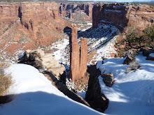
So, to catch up, I've done the same hike I did first in the park, Smith Springs loop, three times now, once with Budd. The color gets prettier every time. Here's a picture that Budd took of me on the back half of the loop last Saturday:


Between my first and second hike in this area, I did one around what is known as the Foothills/Frijole loop. That was a little iffy, as it was five miles and I was wearing new boots. Crazy way to break in boots, yes? But all was well. The photos from that hike aren't as interesting to me now that I've done one more, so we'll skip those.
The last trail I've done up to now was Devil's Hall trail. I'll share those, because some of them really show the gorgeous color that's developing in the canyons up here. Even though I'm only about a mile, mile and a half southwest of the Smith Springs/Frijole area, the vegetation is completely different. Here's the start of the trail. See? Already there are trees!


It didn't take long to round the corner and get into the part of the canyon that's more or less hidden from the campground where the trail starts. This is where I slowed down and just enjoyed being out in the cool fall day, a 4.2 mile round trip ahead of me. It's too tiny in this picture to see, but there is actually a patch of snow in the saddle where the shadow is deep all day.

Looking back behind me toward the Visitors Center and highway, I could see how the side of the wash that was protected by the higher peaks to the south and west was very densely vegetated, while the side that took the brunt of the afternoon sun was more desert-like.

This trail splits into 4 different directions after maybe half a mile. Leading to the left (south/southwest) it goes around El Capitan and out on the southernmost rim of the reef. More west/southwest it climbs to Guadalupe Peak, the highest point in Texas. Continuing due west it drops into the wash and follows it to Devil's Hall, and west/northwest it becomes Tejas trail, which is the major east-west trail in the park. A hardy hiker can reach Dog Canyon on Tejas Trail, 12 miles distant by trail, but over 120 by road around the north end of the park, crossing into New Mexico on the way.
I caught some photos of the beautiful fall color on the way, before reaching the bottom of the wash. And was reminded once again that Budd's little digital camera can't do justice to the color. Or maybe it's that my polarized lenses make it look more intense.
I caught some photos of the beautiful fall color on the way, before reaching the bottom of the wash. And was reminded once again that Budd's little digital camera can't do justice to the color. Or maybe it's that my polarized lenses make it look more intense.


Before leaving on this trek, I had dropped by the Visitor's Center for a book that described the trails in detail, and had overheard the ranger telling another couple to continue past Hiker's Staircase to get to Devil's Hall. When I came to this feature, I thought perhaps it was the Hiker's Staircase. After all, it looked like one, especially from the bottom once I had descended.


It turned out that this wasn't the one, nor was the next one on the trail, that I didn't photograph. I might mention here that there were plenty of other hikers on the trail, something I was grateful for, always being mindful that if I do something stupid and break a bone, I'll be dependent on rescue. For that reason, I'm always outfitted to spend the night if necessary, with foul-weather gear, a couple of layers of clothing, two liters of water in my hydration pack, extra high-energy food, and of course my sotol walking stick. I think I look like a dork with all this gear for a short hike, but I mentioned that to the superintendent last week, and he replied quite seriously that for a hike of any length in this area, he always asks himself if he's prepared to spend the night. Because the weather can change in an instant, blowing up over the escarpment with no warning, it's not a bad idea. Most of the other hikers have backpacks, too, so I guess we all look like dorks, and that's ok.
The trail took quite a long way to get to the bottom of the wash, and when it got there the boulders looked forbidding, but by watching carefully where I stepped, I located the path. It soon broadened to what looked like a paved highway by comparison.

Then again there were a couple of places, like this one, where it looked like I had reached a roadblock.

Looking around, I first tried going to the right, but the step up proved too high for my short legs, and there was no good way to use my hands to climb. I put my 4-foot stick against the vertical wall for perspective and backed off to document this problem.

It's hard to see, but the lighter area of smaller rocks and gravel that look like a step--aren't. Take my word for it, this wasn't going to work. Eventually I decided to use the boulder on the left side of the diamond-shaped one the same way I would go around a slick-rock ridge--around the side, using small depressions to place my feet. Coming back I had to laugh, because there was a reasonable trail even further to the left and higher, that I had missed altogether. Let's just say it wasn't well-marked, but it was far easier to descend than to ascend.
The bottom of the wash was very shady, so I didn't take many more pictures until the trail reached what turned out to be two narrow fins in the reef that had been cut through by the wash. From one point, I could see that it opened out into a broader area, almost a hidden canyon. I had come completely around the northeastern escarpment and was behind the bluff you can see from the road.


Passing through between these fins, I finally found Hiker's Staircase.

I had just passed a couple of hikers coming back out, who told me the end of the trail was about 200 yards after you ascend the staircase, which I did using both hands and feet to scramble up. I'm sure younger people with longer legs just go up it like stairs, but I didn't feel stable standing upright, as the strata slope slightly downward, so I abandoned dignity for safety.
It wasn't until I had read more in the book I bought that I realized a narrow slot I passed through was the Devil's Hall formation the trail was named for, so I didn't take a picture from the going-in side. As you come out, this is the vista. The sign says, appropriately, End of Trail. Really?

I found a broad table-like rock from the same stratum as the stairs and set out my picnic lunch, chatting with another party of hikers as they also took advantage of the end of the trail to pause for some rest and food. Since we were departing about the same time, I asked them to go ahead of me so I wouldn't hold them up, and agreed to take a picture of the three of them on their camera. It was then that I noticed the spectacular nature of the Hall, including how the light at the opening reflected from the east wall to the west one, and the tree framed by the opening.


Coming out, I also noticed a feature that I'm used to seeing only in sandstone, instead of the limestone that forms the bluffs and escarpment here. Had to zoom in to make it viewable on a small screen.


I guess there are arches or natural windows almost everywhere if you know where to look for them! As the time was getting away from me and I had to be back for a tutoring shift, I focused on walking faster on the way out and didn't take any more pictures.
I'm feeling stronger and not having to wait so long between hikes any more, so yesterday I ran out to quickly do the nature loop at McKittrick Canyon, which is my next target. Didn't think to take the camera because I was going more for the cardio and just completing it than for the views, but I regret not getting shots of a couple of features that I found interesting.
Tomorrow Budd and I are going into McKittrick Canyon itself. We compromised on the hike, as I wanted to go all the way to the Grotto, which is reportedly an easy hike, if long at just under 7 miles round trip. He's not fond of hiking after all, but is willing to go with me if I'll turn around at Pratt Cabin, making it only a 4 mile round trip. I'll do that with him, and then go back for the longer hike on a weekday.
Speaking of Budd, he just came home for lunch, and here I sit not dressed for the day yet, having been online all morning. Guess I'd better get going!
No comments:
Post a Comment