Friday, October 22, 2010

October 22, 2010

First Guadalupe Hike!

I promised pictures and an account of my first Guadalupe Mountains trail. So here goes:

For anyone who wants to know more about the park itself, here's the link to the official site: Briefly, the mountains for which the park is named are composed of a prehistoric reef, which was first buried by sediments and then slowly uncovered over millenia. It has migrated northward from near the equator, and has guided modern peoples including the Native Americans, early westward-bound travellers and outlaws, for centuries. It contains Guadalupe Peak, the highest location in Texas at a little over 8700 feet, as well as El Capitan, the most recognizable landmark for miles and miles around.

As I've mentioned previously, there are 80 miles of 'maintained' trails here, some that are too arduous for us to tackle right now, and some that are quite manageable. For my first hike, I chose Smith Springs Loop, which begins and ends at this historic ranch house, quaintly named Frijole Ranch, where a museum now resides. The museum was closed, so that is something we'll do another day.


From here, the trail leads back toward the west and the reef, into a draw where there is a spring that is fed by an underground reservoir contained within the limestone. As desertification has taken place over the years, this spring is an important aquifer for the wildlife in the area. The loop is 2.3 miles.

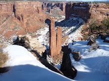
Warned to watch for rattlesnakes and wearing walking shoes more suited to sidewalks and city pavements, I was careful to watch my footing, so the few photos I took along the trail represented times when I stopped to look around, get my bearings, and see what I was missing as I walked with my eyes to the ground. The first one is of El Capitan, which was to my south at the point where I took the picture. It is the left-most ridge that looks almost as if it has been squared off from this angle.


As you can see, it was a cloudy day and I had been told I was bound to get wet. That proved true after a fashion. The hiking was relatively easy except for having to watch my footing to make sure a rock didn't roll away and make me twist my ankle. There was a little incline, but quite easy. The trail led around a little hill and then down into the first draw where an intermittent creek had left a pathway. Looking up it a few yards I spotted the first indication of fall--a maple that had turned it's leaves. A little further beyond was a Texas Madrone, the tree that looks like it has a snake dangling from it--which now that I can see the post, I can tell you can't really see, lol, just a whitish splotch in the center of the photo. That's actually a branch. This tree sheds it's reddish bark in long strips, providing fibers for the Native Americans to make baskets. It also has masses of red, edible berries, though in this picture they are too far away to see. This is called the Transition Zone, because you can also see the desert plants next to those from the higher elevations, as represented by the yucca that is wearing a self-generated grass skirt.


At this point I thought I had reached the spring, since I had no way of knowing how far I had come. I was a little disappointed to find it dry, but assumed I was halfway and continued across and up the hill. And around the hill. And back down the hill, until I came to this pool. When I took the picture, it was my intention to show the water, but now that I look at it, the more interesting part is the downed and blackened tree. This park lost thousands of acres of pine forest to a man-caused fire about fifteen years ago, hastening desertification by who knows how many decades.


A few steps further along brought this vista. I spent a few minutes here trying to capture the little rills of spilling water, all of which turned out blurry. Later I figured out how to compensate for my elevated heart rate while taking zoomed-in photos, but alas, not here.


Continuing across the spring on this path,


I finally came to the actual spring. where I spent quite some time trying to see where the water was falling behind this overhanging branch.


Then I got a different perspective, still trying to see the water, but at least the roots of this tree are interesting.

Here is where I also finally got wet, a function of what an Arizona friend has dubbed a 10-inch rain: one drop of water, 10 inches apart, every 10 minutes. So I didn't get very wet. I also had to take a peek through the trees to see up-close some of the remains of the reef. Along with a little more fall color, of course.


By this time I realized I had been spending a lot of time taking pictures and looking around, and Budd would be worrying as I had said I should be back in an hour and a half. So I reluctantly left this peaceful grotto and set out to finish the trail. But I couldn't resist a few pictures that just seemed to represent fall in the Transition Zone, with tall pines, colorful maples and a sotol from the desert (the spiky plant in the foreground).

Looking back up the draw, I decided it had been a good day's cardio getting into and back out of that draw.


Soon I was back at the ranch house, after passing another spring, very close to the house, that had been dammed up for a swimming hole for the historic occupants. It was too marshy to get in and get good pictures, but here's a taste.


Later that evening, Budd and I were watching TV when we heard distant rumbling and went out to see what was going on. The forecast thunderstorms had finally started, so we went out into the car and watched for quite a while. I took 72 pictures trying to catch the rare lightning bolt that showed itself below the clouds, with no success. But I did get a few good shots of the lightning ABOVE the clouds. Here's the best, to end with another view of the ever-changing El Capitan.


Hope you enjoyed hiking with me!

Thursday, October 21, 2010

October 21, 2010

Howdy from West Texas! Of all the possibilities that were mentioned to us as Budd’s next assignment, the last thing we expected was to find ourselves in Texas. But here we are, at Guadalupe Mountains National Park, one hundred and ten miles or so east of El Paso, and about 60 miles south of Carlsbad, NM. And, barring permanent employment becoming available, here is where we expect to stay until at least mid-December. At this point it’s too far in the future to speculate what happens after that, but the prospects are good for continued temporary employment with the Park Service.

During our second sojourn at Canyon de Chelly, I rediscovered hiking. I don’t recall loving hiking for its own sake when I was a kid, but I do recall scrambling all over the cliffs comprising the eastern boundary of Moab, UT where I grew up. I was twelve years old the summer we moved there, soon to be 13. We lived in a duplex owned and also occupied by my uncle and aunt, and my brother, sister and I were delighted to find our family more than doubled by our cousins. Weekends and almost any summer day found us trekking up the trail and over the lip of the first bench of the cliffside, across a sandy and rocky more-or-less level area, up and over the second bench and then far across the sand to what was then known as Lion’s Back, a ‘slickrock’ fin that was part of a complex of them. From there, depending on my climbing companions, we often climbed up that and felt we were at the top of the world. I guess I did love hiking, I just didn’t think of it in those terms then.

When I hiked and climbed down and then back up Bare Trail in Canyon de Chelly, another 'slickrock' venture, it woke up that old feeling of accomplishment, enjoyable effort, and slight danger. I think it must be a minor version of what daredevil adrenaline junkies feel. Whatever the case, I couldn’t wait to do another fairly challenging hike. When I learned we were coming here, of course I researched it on the internet, and learned there are 80 miles of ‘maintained’ trails. Having hiked the first one of any consequence yesterday, I’m wondering what they mean by ‘maintained’, but I’m getting ahead of myself. First the trip here…

We packed up at Canyon de Chelly last Saturday and drove to Albuquerque. I wanted to get my hair cut—Budd wanted to get to the casino. We both wanted something to eat, so he won. After eating at one of the restaurants in the casino, we sat in the lounge for a while as Budd remembered that he couldn’t get a drink at the tables in the Sandia casino—it’s Indian-owned. After ascertaining that Utah was going to win their game (Utes—college football) and Boise State was blowing away whoever they were playing, I decided to go ahead and find a table. Blackjack was calling me! Budd joined me after a while and we played here and there, sometimes at the same table, sometimes not, for about three hours. At the end of that time after tipping the dealers, the girl who brought water and the cashier, I was up $3. Just about right to tip the shuttle driver and go home with exactly the amount I sat down with. I call that a good day at the tables! Budd’s luck didn’t hold that well, but that’s another story! Just kidding, he didn’t lose more than it would have cost us to go to a movie. For an evening’s entertainment, we did pretty well.

The next day he wanted to veg out, so I took the opportunity to get my hair cut, then went and rewarded myself with a manicure and pedicure. Rewarded for what, you ask? Why, thank you for asking! I was celebrating more than 15 pounds of weight loss—25% of my total weight loss goal. I’m ahead of schedule, so I’m feeling quite pleased with myself. As of today, I’ve lost 10% of my starting body weight. According to the articles I read, I’ve lowered my risk of diabetes, heart disease and a lot of other unpleasant stuff by about 50%.

Which brings us to Monday. We were having a rather leisurely morning, preparing to get back on the road, when Budd discovered that instead of the four hours of driving we thought we had ahead of us, it was closer to six. We also thought we’d be losing an hour with a time zone change, which turned out not to be the case, but it jump-started us to get out of there in a hurry! We didn’t want to be locked out of our new digs by getting to the park after-hours, and we knew we’d have to stop in either El Paso or Carlsbad, depending on our route, for groceries. There isn’t a town anywhere near here, so no grocery store, no restaurant. Mapquest claimed it was faster to go through Carlsbad even though we wouldn’t be on an interstate highway, so we set out. Fortunately, the highway is divided most of the way, so Budd’s objections were unfounded.

We are traveling with a bare minimum of possessions in a Buick sedan with a large Sears car-top carrier, stuffed to the gills. Unfortunately, our car was not designed for a car-top carrier, so what Budd rigged to hold it up there creates tremendous road noise. At one point it sounded like someone was crouched on top of the car beating a tattoo on the roof with drum sticks. We lost a little time in Roswell trying to find a solution for that. All I can say about Roswell is that it is the stinkiest place I’ve been since Draper, UT lost it’s dairy farm on the main drag. Whew! Nasty.

Back on the road with a whistling noise instead of snare drums, we drove on. And on. And ON! We finally reached Carlsbad at a little before 4 p.m. At this point we called the park and were given the superintendent’s number to call when we got here. So we hurried through Walmart, throwing into the grocery cart what we would need for the next 5 days until we could get back. I arrived with tilapia and tortillas for fish tacos, but no cabbage; bread for toast, but no butter. I had meat for spaghetti, goulash, and vegetable beef stew, but only one can of tomatoes, which I used in a chicken dish. Today is Thursday and I have no idea what I’m going to cook for dinner for the next two nights.

We arrived at the park housing area and turned in circles until we could find a stable cell signal to call the superintendent, who came right over and let us in. Here we got our first pleasant surprise. Though it’s only a one-bedroom apartment and both computers have to grace the living room, it’s quite roomy, clean, and the floor is carpeted! Palatial compared to the Canyon de Chelly house—and there’s a dishwasher! Unfortunately, the DSL had not been installed, despite my ordering it earlier, and in fact we are still waiting for it. Fortunately, the park provides wifi at the visitor center, and I’ve been allowed to use a carrel in the employee library with the laptop. Although it isn’t as convenient as having internet at the house, at least I’m not completely incommunicado. I get three bars on the cell signal about a quarter of a mile from the house, too.

Yesterday morning, finally settled in and with the business aspects of the move handled (call and complain to the phone company about having to wait for DSL, call DirecTV to tell them we’ve moved again so they can send us the local channels, unpack, re-arrange kitchen to suit myself), I FINALLY got on a trail for a nice hike. It was reportedly a 2.2 mile loop, so I told both the interps at the VC and Budd (who happened to pass through the VC as I was leaving) that I should be able to cover that in an hour and to come looking for me if it was more than two. I didn’t really count on taking as long to look around and take pictures as I did! The trail I took is well-defined, but at times is no more than about 10 inches wide, passing through dense underbrush or grasses in spots. I was told to watch for rattlesnakes (note to self: must get hiking boots!) and be on the lookout for mountain lions. Between those admonitions and the chance for thunderstorms, I decided to heed the advice of hikers in rougher, more isolated terrain: tell someone where you’re going and when you expect to be back--and I’m glad I did. But next time I’ll build in some rest time, look around time, and photo time!

I’ll share a few pictures when I can, however I have no way to get them from the camera to the laptop, so it will have to wait until the DSL is installed and I can use the desktop. I'll provide a narrative of the hike then, too.

By the time I was back at the trailhead, I had been gone 2 hours and 10 minutes. I figured I’d better go check in at the VC in case Budd asked if I had gotten back, but then I needed to get some lunch and charge my phone, which discharges the battery rapidly while searching for signal. I assumed he had been to the house for lunch and was back at work before I was due in. However, he was late, and believing I had started earlier than I had, he got worried that I wasn’t there. So he and the employee he’s replacing went to the trailhead, where I had been just a few minutes before, to look for the car. Not finding it, they went to the VC, but they took a service road, while I was parked in the visitor parking lot. We must have missed each other by seconds! Fortunately, the interp that I had checked in with was able to tell him I was safe, so all was well. Later we again met by accident when I went back to the library to finish my internet tasks. What a circus!

The forecast for yesterday was for 40% chance of thunderstorms, growing to 60% by evening. I got sprinkled by a few raindrops on the hike, but the real fireworks didn’t start until about 8:30. It was so spectacular that Budd and I sat in the car for almost an hour to watch and try to take pictures. Our camera isn’t really up to the task, but we did get one or two good ones.

Today dawned sunny with a few leftover clouds. After getting to the VC to post this, I’m going to find out if the trails will be too muddy and maybe do another hike today. We’re told that any day now strong winds will make it too unpleasant to hike until next summer, so I want to make use of all the good days I can. I’m quite disappointed by that news, as the temperatures look like it would have been pleasant to hike right up through mid-December. But it is what it is, so we’ll do as many miles of those trails as we can, and save the rest for another time. Look for shorter posts more often for a while as I plan to narrate and illustrate the hikes as I do them.


Friday, October 1, 2010

October 1, 2010

Please forgive the awkward composition where the pictures have been pasted in. I cut and pasted this from my weight loss site, where I composed it first. I'm too tired from the hike to figure out how to fix this one...

Though there are many inconveniences to living as we do, one of the delights is that every week or so, I get the opportunity of a lifetime. When DH first told me about this one, I never imagined I could or would do it. One of the Navajo guides who are licensed to work in the canyon was scheduled to lead a party from the top of the South Rim into del Muerto Canyon, up the other side of the canyon and across the peninsula that separates del Muerto from de Chelly, down that side and back up White House Trail, which was the trail we took on September 11. Although it was only 5 or 6 miles as the crow flies, the hikers would drop and climb up at least 600 feet in elevation twice, and cover a total distance of about 12 miles. For anyone who would like to see a map of this area, one can be found here: www.nps.gov/cach/. Zoom in until you can see White House Overlook, then look just a little east of due north for Ledge Ruin. Half a mile or so west of Ledge Ruin, around a very narrow ridge, is where Bare Trail drops off the canyon wall into the wash.

Yesterday, Budd came home with the news that a couple of the ladies who work at the visitor center were going to do the first part of the hike, then go back UP Bare Trail while the others went on. The only catch was that I would have to be at the visitor center at 6:45 a.m. to join them. I'll admit I wavered. This was still going to be a very strenuous hike, and I wasn't sure I was up to it. But with the thought that I would hate myself if I passed on this opportunity, I prepared for it before going to bed at a suitably early hour...just before 11 p.m.

5:30 a.m. found me awake and anxious. Could I make it? Should I even try? What if I held the others up, or worse yet, someone had to accompany me out before we reached the bottom? Let me stress that this is a trail only in the sense that the locals know where to climb down and up, and that there are a few steps or hand-and-toe holds carved into the rocks at intervals along the way. This was going to be a climb! But in the end the knowledge of the pain of regret got me out of bed and through breakfast, in time to be first at the visitor center, waiting for the others to arrive.

Our guide was the last to arrive, about half an hour late, so it was not until 7:30 a.m. that we arrived at the 'trail head', parked the vehicles, and set off. From the top, I tried to take a picture down into the canyon where we would be going, but the sun was in an awkward position, so it's hard to see the result.

The wavy layers of sedimentary rock at the bottom of the picture were sloped enough that my feet pointed down as if I were on tiptoe as we took this part of the 'trail' down to the edge where the bright rock ends here. From this point over to the south, I didn't have time to take pictures, as the rest of the party was setting quite a pace, and I was picking my way along an edge that seemed no wider than my shoes, some yards behind them, and leaning into the uphill side of the rock with all my focus on not looking down.

Until we arrived here.

Yes, we were going over the rim here, and it was only wide enough for one, so I was able to get a vista shot as the others descended. In the distance, to the left of what may be too small to recognize as a cornfield, and directly below the tallest cliff on the other side, is the round dome rock where Budd and I were standing in the picture I posted a couple of weeks ago. And yes, we're going down there. However, I have performed a little trick of the eye with the camera. Below the rim in the foreground is a V-shaped drainage chute, with steps carved either by Navajos or wind and water, so that it was actually a very easy descent. The others made it like a staircase...I scooted down using my butt, hands and feet.

After a rather hair-raising descent down hand-and-toe steps that had to be negotiated by dropping over a rim and turning around with my face to the wall, we arrived at the slide, where the rest of the party stopped to hear the guide explain that this one, which was about 14 feet long and had only a slight slope (look at the feet in the picture for an idea) was where younger children play when their chores are done.
He then described a longer one, about 70 feet and ending in a sheer cliff, where the teenagers play. I thought it best not to ask the question on the tip of my tongue...how many do they lose each year...as the farm below belonged to the guide's family, and I'm sure it was his young nieces and nephews who were doing the sliding. I used the time to catch up to the others and take a couple of pictures. From here I knew I could do it, because this is where we were on Sunday, the 19th.

I also took the opportunity to get a better shot of the stairs carved into the opposite cliff wall (the wavy line to the left of the cave). Thank goodness we weren't going up those!

Once at the bottom, we decided to go about 1/2 mile up the wash with the rest of the party before they turned around, and shortly arrived at Ledge Ruin where we stopped for a while before heading out, leaving the main party to go on another 1 1/2 miles before ascending on the south side. On the way back, I took advantage of a clearing to get a shot of where we came from. Although he is too far away to see, the ranger who shuttled most of us to the trail head is at the top, and turned out to be invaluable in getting us back up there, as the trail is unmarked most of the way. No, you can't see the way we came down from this shot, but the top is where we walked along until we got to the chute where I had to scoot down on five-point contact.

And here is the moment of truth. I will finally be brave enough to post a picture of me from the back, as I handed Nora the camera to record for posterity my posterior climbing back up the hand-and-toe ladder that had given me pause coming down.
MUCH easier to go back up, although I have to say my heart was at times beating so hard I could hear it echoing off the canyon walls. But with stops to get my breath, and Fernando to scout the way, we made it. We were about halfway up at this point, and I didn't take many pictures after this.

Along the way I slipped and started to lose my balance, so to avoid taking a nasty tumble of about 6 feet, I put my hand down, unfortunately neglecting to look where I was putting it. I got a number of tiny sticker spines in my right hand for my trouble, and was a little handicapped when the climb up required a scramble on hands and feet, so picture-taking was the last thing on my mind. The things on my mind were, in order:

1) Are we there yet?
2) I REALLY could use a restroom about now
3) I can't believe I did this!

We arrived back at the top at 11:30 a.m., 4 hours almost to the minute from when we had set out. Give me a week to recover, and I want to do it again!

PS As I write this, a violent wind and sand storm has blown up with accompanying rain clouds. Thank goodness the others expected to be back to the top of South Rim about an hour and a half ago!