Yesterday I formed the determination to get to the top of Guadalupe Peak today. I had several reasons. I had made almost 1/3 of the altitude gain with little problem on Wednesday, but turned around because I thought I was on the wrong trail. I had done very little in the way of exercise during the rest of the week. And I got the idea in my head that today was the right day because tomorrow I will turn 62 years old. It just seemed somehow appropriate that I had been born at one of the lowest altitudes in Texas in Corpus Christi and would celebrate the last day of my 61st year at the highest.
Alas, it was not to be. But I'm ok with it. It's actually kind of funny.
The first thing I did was wake up to the howling that signals high winds. This was not supposed to happen! The forecast didn't say WINDY until tomorrow! So I looked at TWC online to see just how fast they were blowing. 22 mph. Well, that's not so bad, is it? I stepped outside with Budd as he left for work just before 8 a.m., quite breezy, but not cold, in spite of the temperature showing at 35 degrees. OK, I'm going to try it, but I'll be prudent. I'll stop at the Visitor Center and ask a ranger whether it is too dangerous.
Rushing around to get my breakfast and prepare my pack for an 8-mile hike, I left the house at ten minutes of nine and drove to the VC. Asked the first interp I saw, a fit-looking young man, about the winds. 'Naaaah,' he says. 'We don't worry about the winds until they're gusting above 55 mph. You should be fine. Lean into the mountain, make sure you have a hat strap (I didn't) and plenty of water, because the wind will dry you out. You'll be fine.' Since I didn't have a hat strap, I would have to take off the hat, but he told me to take it with me for the calm spots. There's no shade to speak of on the trail.
I got back in the car, applied sunscreen and drove to the campground, where I put my hat in my pack, turned on Bigmouth, signed the trail register and headed back up the same trail I had been on day before yesterday, which I had determined was indeed the right trail. I was very pleased that even with the wind I made the point where the sign was located (see Wednesday's blog for the picture) in under 45 minutes, as my 9 a.m. BodyBugg alarm hadn't gone off yet. I made the sharp right turn where I had turned on Wednesday, and soon realized I had passed my previous turnaround point without recognizing it. I was on a previously untraveled (by me) track that led back into the canyon.
In the harsh morning sun I didn't find anything I was particularly interested in photographing, so unfortunately there are no pictures to document this hike. Just as well...I wasn't going where I thought I was going. It soon became apparent that I was going steadily if not steeply downhill. I kept thinking that any minute the trail would turn upwards. Because the trail followed on the same side of the mountain as the wash where Devil's Hall trail wanders, I assumed that somewhere back in the canyon it would begin ascending from the west. Because it was only slightly downhill, it was fairly easy walking, except for the times I felt I didn't want to be moving as a gust of wind caught me. At those times, I'd plant my stick in front, take a wide-legged stance and wait it out. I was quite stable, no chance of being blown off the side of the mountain.
Before very much longer, I was getting a little agitated. I hate to lose altitude when I still have quite a bit to gain, so I was not liking the downward trend on this trail. Suddenly, I spotted a sign up ahead. Good! I'd be able to orient myself from here. Striding the last few yards, I eagerly looked at the sign. What?! Guadalupe Peak back the way I had come, Devil's Hall straight ahead...how the heck? I had found the sign that I remembered on Wednesday (except there was no Tejas trail access to the right), but where had I gone wrong? I hadn't been anywhere near the summit on Guadalupe Peak.
Now I had a decision to make. I had come quite a ways DOWN, on the wrong trail, when the trail I wanted was already an 8.5 mile trek. That's longer than I've gone before. Should I climb back up, looking carefully for where I missed the turn I should have taken? I sat down to take off my pack and consult the map. That's when I remembered I had taken the map out of my pack on Wednesday, to try to figure out what I had done after I got home. I hadn't put it back.
Discretion became the better part of valor as I turned back to the east on the return trail to the campground. I was disappointed, but there were just too many things working against me to correct my mistake today. Not only the wind and the lack of a map, but an extra two miles? Not gonna happen.
As I strode along, making great time on this trail, I decided to take Bigmouth in to show the VC ranger, and make sure I knew what I was doing next time. Oh, yeah, there will be a next time! I'm not letting this defeat me. I got to the VC, walked up to the big map on the counter and found it...Bigmouth's trackback was a perfect match for, wait for it--THE HORSE TRAIL! I finally know where that guy came from! (Wednesday's blog again.)
I was home in time to have lunch with Budd, but I have every intention of taking that hike on the next low-wind day. The two and a quarter miles today took only 2 hours and burned 688 calories! I'm getting there,
Now I think I'll cross-stitch all afternoon--I've earned it!
Friday, November 19, 2010
Thursday, November 18, 2010
November 18, 2010
I was SO happy to get back on a trail yesterday morning. It had been a week and a half, and I was having withdrawal symptoms. Not to mention the undeniable fact that it doesn't take long for a senior citizen to lose conditioning. I hadn't been on the trail more than 5 minutes before I was huffing and puffing like the little engine that could.
My destination, for the first time, was not the end of the trail. I had decided to tackle a 'strenuous' trail, which in this case means steep. The end summits Guadalupe Peak at 8751 ft. according to the latest calculations. Not only had I started out too late in the day, but I was by no means certain I was up to the 8.4 mile round trip. The last hike, at 6.8, was very tiring, and it was basically flat. So today, my intention was to go as high as I could before my legs turned to jelly, then turn around and come back.
Since I didn't know how far that would be, I decided to take Bigmouth (our GPS, who is female) along. She has a usage mode for walking as well as driving (also bicycling and scootering, whatever that is--why would a scooter be different from a bike?), but we haven't used it much, so I wasn't certain what I was doing. I started by saving my location at the campground/trailhead parking lot, and taking mental note of the elevation (which I promptly forgot). The internet tells me it's 5633 feet. Then, leaving her on, I put her in my backpack. She is a car model, not suitable for carrying, and I didn't have a pocket. Fortunately, she did track me as I walked.
The trail from Pine Springs campground divides several times, the first time within sight of the trailhead. From this division, you can take Devil's Hall trail, which branches off to Tejas trail a little further along. You can take El Capitan trail, leading back to the east and south around the famous formation and back in a loop. Or you can take Guadalupe, which clearly states no horses on this trail. I set off in the direction of the arrow, and no more than five minutes later ran into this bloke and had to step off the trail to leave room for his horses. Where the heck had he come from?

As I pondered that question, I began to believe that there was another branch of the trail ahead, right to Devil's Hall and left to Guadalupe Peak and El Capitan. I should never trust the map that's in my head, although it's pretty good most of the time. Sometimes the gremlins in there turn it around. But I could hear voices from up ahead, so I knew I wasn't alone on the trail, a comforting thought as I'm always aware that I could require rescue even for a relatively minor injury.
Soon I began to realize that I wasn't recognizing this trail, which I thought I should, still believing it hadn't divided yet. I had done Devil's Hall just a couple of weeks ago. Stopping to look around, I realized that I had somehow passed the sign for Devil's Hall. Duh, I had done that at the first fork in the trail, but I wouldn't figure that out until I came back down. As the trail led upward, steeply, and back around to the east and south, I began to suspect that I had somehow taken El Capitan instead of Guadalupe. Finally, I reached this point, where I decided that I would turn around at the sign up ahead, no matter what it said.

I knew I hadn't been out long enough to have made more than a mile, but I'm always, always aware of safety. I didn't want to risk injury on the wrong trail, when rescuers would be looking for me where I had left word I'd be going. And the trail was getting VERY steep. Although going UP a steep trail is more strenuous, going DOWN a steep trail is more treacherous. Going up a step that is uncomfortably long for my short legs merely requires me to lever myself up with my stick. Going down them means landing hard on rocks that tend to roll with you.
When I got to the sign, I had to laugh. It said 'No stock beyond this point.' Where HAD that guy come from? Looking out, I came to the conclusion that I was definitely on El Capitan trail, where I didn't want to be at this time of day, exposed to the afternoon winds and sun. I decided to go just far enough further along to find a shady place to sit down and have lunch, and check with Bigmouth on elevation gain and distance if she would tell me that.
No luck with the distance, but I was at 6603 ft. I had gained 970 feet in what I later tracked on GoogleMaps as right around .87 miles! As I write this, I'm thinking, I could do it! I could get all the way to the end of the trail. I just need to start quite a bit earlier, and have faith I'm on the right trail. And give myself time to rest often. And maybe have a hiking buddy.
So, I wolfed down my sandwich and started back down, first donning my sweatshirt as the wind was picking up and was quite chilly. Going down was faster because I didn't need to rest, but as I mentioned, treacherous. At least three times I had to catch my balance as my feet tried to slide out from under me. Yay for the balance games on the Wii Fit! I made it with no embarrassing one-point landings.
Back at the fork in the trail where I had chosen the middle path, I confirmed that it was indeed Guadalupe Peak. I think. When I got home, I compared the trackback path on the Garmin to the trail I tracked on GoogleMaps, and the squiggles look exactly the same. I may have gone a few feet further or a few feet less far, but we'll call it good. My main goal had been to walk partway up a steep trail, done, and burn 500 calories. The fitness tracker on SparkPeople only credited me with 385, but I don't know how to tell it about that 970 ft. elevation gain, or the 9 lb. backpack I was carrying. BodyBugg told me I burned 515. Good enough!
My destination, for the first time, was not the end of the trail. I had decided to tackle a 'strenuous' trail, which in this case means steep. The end summits Guadalupe Peak at 8751 ft. according to the latest calculations. Not only had I started out too late in the day, but I was by no means certain I was up to the 8.4 mile round trip. The last hike, at 6.8, was very tiring, and it was basically flat. So today, my intention was to go as high as I could before my legs turned to jelly, then turn around and come back.
Since I didn't know how far that would be, I decided to take Bigmouth (our GPS, who is female) along. She has a usage mode for walking as well as driving (also bicycling and scootering, whatever that is--why would a scooter be different from a bike?), but we haven't used it much, so I wasn't certain what I was doing. I started by saving my location at the campground/trailhead parking lot, and taking mental note of the elevation (which I promptly forgot). The internet tells me it's 5633 feet. Then, leaving her on, I put her in my backpack. She is a car model, not suitable for carrying, and I didn't have a pocket. Fortunately, she did track me as I walked.
The trail from Pine Springs campground divides several times, the first time within sight of the trailhead. From this division, you can take Devil's Hall trail, which branches off to Tejas trail a little further along. You can take El Capitan trail, leading back to the east and south around the famous formation and back in a loop. Or you can take Guadalupe, which clearly states no horses on this trail. I set off in the direction of the arrow, and no more than five minutes later ran into this bloke and had to step off the trail to leave room for his horses. Where the heck had he come from?
As I pondered that question, I began to believe that there was another branch of the trail ahead, right to Devil's Hall and left to Guadalupe Peak and El Capitan. I should never trust the map that's in my head, although it's pretty good most of the time. Sometimes the gremlins in there turn it around. But I could hear voices from up ahead, so I knew I wasn't alone on the trail, a comforting thought as I'm always aware that I could require rescue even for a relatively minor injury.
Soon I began to realize that I wasn't recognizing this trail, which I thought I should, still believing it hadn't divided yet. I had done Devil's Hall just a couple of weeks ago. Stopping to look around, I realized that I had somehow passed the sign for Devil's Hall. Duh, I had done that at the first fork in the trail, but I wouldn't figure that out until I came back down. As the trail led upward, steeply, and back around to the east and south, I began to suspect that I had somehow taken El Capitan instead of Guadalupe. Finally, I reached this point, where I decided that I would turn around at the sign up ahead, no matter what it said.
I knew I hadn't been out long enough to have made more than a mile, but I'm always, always aware of safety. I didn't want to risk injury on the wrong trail, when rescuers would be looking for me where I had left word I'd be going. And the trail was getting VERY steep. Although going UP a steep trail is more strenuous, going DOWN a steep trail is more treacherous. Going up a step that is uncomfortably long for my short legs merely requires me to lever myself up with my stick. Going down them means landing hard on rocks that tend to roll with you.
When I got to the sign, I had to laugh. It said 'No stock beyond this point.' Where HAD that guy come from? Looking out, I came to the conclusion that I was definitely on El Capitan trail, where I didn't want to be at this time of day, exposed to the afternoon winds and sun. I decided to go just far enough further along to find a shady place to sit down and have lunch, and check with Bigmouth on elevation gain and distance if she would tell me that.
No luck with the distance, but I was at 6603 ft. I had gained 970 feet in what I later tracked on GoogleMaps as right around .87 miles! As I write this, I'm thinking, I could do it! I could get all the way to the end of the trail. I just need to start quite a bit earlier, and have faith I'm on the right trail. And give myself time to rest often. And maybe have a hiking buddy.
So, I wolfed down my sandwich and started back down, first donning my sweatshirt as the wind was picking up and was quite chilly. Going down was faster because I didn't need to rest, but as I mentioned, treacherous. At least three times I had to catch my balance as my feet tried to slide out from under me. Yay for the balance games on the Wii Fit! I made it with no embarrassing one-point landings.
Back at the fork in the trail where I had chosen the middle path, I confirmed that it was indeed Guadalupe Peak. I think. When I got home, I compared the trackback path on the Garmin to the trail I tracked on GoogleMaps, and the squiggles look exactly the same. I may have gone a few feet further or a few feet less far, but we'll call it good. My main goal had been to walk partway up a steep trail, done, and burn 500 calories. The fitness tracker on SparkPeople only credited me with 385, but I don't know how to tell it about that 970 ft. elevation gain, or the 9 lb. backpack I was carrying. BodyBugg told me I burned 515. Good enough!
The weather forecast shows today and tomorrow sunny with relatively little wind, meaning it's below 20 miles per hour. Starting Saturday (my birthday!) it shows just WINDY until after Thanksgiving. I'm going to have to get creative for my cardio for the next week so I don't get bored. Then Thanksgiving in Dallas with my family! I can't wait...but first I'm psyching myself up to attempt Guadalupe trail again tomorrow.
Monday, November 15, 2010
November 15, 2010
I've slowed down some on my hiking, to Budd's great relief. On the 6th we went to do the McKittrick Canyon hike that I was planning last time I blogged, and found a backup waiting to get a parking spot at the trail head. The volunteer who was trying to keep the tourists mollified told us that they figured it would be an hour before anyone started coming out. Not willing to wait that long, I suggested we do Devil's Hall, and we drove the 7 miles back to the main campground, where we also found both that and the visitor center parking lot full.


This is the best picture of a couple of dozen that I took. It's more of an alcove than a cave...maybe eight or ten feet deep and just high enough for me to stand and walk under the stalactites if I didn't mind getting dripped on. I kept trying to capture a drip of water just as it dropped, but either my reflexes or my camera was too slow...most of those turned out to be blurred or just weird. This one was taken from the top of a mound that was across the path from the grotto itself.

The hike out was a push, as I was concerned about the time. The highway gate to the road leading in is locked at 4:30 during the winter season, and I definitely didn't want to get locked in. So, as I passed person after person hiking IN, I was pushing to get OUT. This hike was 6.8 miles, the most ambitious one I've done yet, and one that I didn't enjoy as much as the first time I've done the others in the park. I don't know whether it was the excessive length, although as it turned out I did it in just over four hours--about the same as Devil's Hall, or whether it was the disappointment after building it up in my mind as something spectacular. In any case, I didn't hike again last week.
Budd said he guessed we could drive to Dog Canyon, so we stopped at the house for maps and set out. Dog Canyon is 12 miles by trail from the visitor center, but it's on the other side of the mountain range. To get there by car, you go back almost all the way to Carlsbad, then across ranch roads and back southwest into Texas, a 120 mile round trip. We left the house at about 11, figuring to get there by 1 p.m., hike a couple of hours and be back before dark. Uh, nope.
First, on the ranch roads, you can't do more than 35-45 average. They are ill-maintained, have loose cattle wandering across, and they wind and turn a lot. By the time we got to Dog Canyon, it was 2:30. We did get out and unfortunately decided to do the nature loop--my suggestion since it was measured and I was thinking about my exercise and mileage tracking. It proved very disappointing, flat, uninteresting, and burned out from a fire that occurred sometime between May and August this year. When we got back to the car, it was too late to actually get on the canyon trail, so that long drive was for nothing, and we still had to get back.
Going back we stayed on a road that brought us back to the highway north of Carlsbad a few miles. We went through gas well fields that had numerous signs warning of the potential for poisonous H2S gas to be present. They said if you smelled an odor, leave the area. The whole area was odiferous! Have you ever tried to hold your breath for 20 miles?
So on Monday, I hiked McKittrick by myself. And learned that it was a good thing we hadn't done it on the Saturday--Budd would have hated it. There was no shade to speak of for the first 2 and a half miles, it was more or less flat, no challenges at all, and no color. What's up with that? Devil's Hall had much better color. The cabin was kind of interesting, but locked, so I could only take pictures of the outside.

All the stones for this cabin were picked up at the mouth of the canyon and dragged up on sleds in the 1930's when Wallace Pratt, the oil geologist who owned the land before giving it to the park service decided to build a summer home here. If you look closely, you can see that even the roof is made of stone. I listened to him narrate a slide show when I returned to the trail head, and as I understand it this is travertine. I'm familiar with travertine as a very desirable flooring tile, so this was impressive to me. I guess if you can just pick it up and don't have it polished to a high gloss like marble, it isn't that expensive. But there were the cowboys who lugged it three miles to the cabin site to pay.
After checking my map while sitting on the front porch, I decided to push on before eating lunch. My watch was acting strangely and I couldn't rely on the time it was showing, so I decided to rely on my stomach instead, even knowing that hiking suppresses my appetite. There was a mile to go to get to The Grotto. This sign tickled my fancy.

I was going into the wilderness! Which turned out to be a well-traveled trail with more people on it at this time than the trek in to the cabin. Oh well. At least they were able to tell me I was on the right track. The trails crew had fortunately stopped the deep bed of river pebbles that covered most of the trail up to the cabin...that stuff is hard to walk in!
I met a couple of characters on this part of the trail. There was the guy in a camoflage shirt who startled me by speaking before I saw him sitting to eat his lunch on a fallen log. He was very apologetic! Then there was the guy who was off the trail down at the water's edge (where the signs ask you not to be) and who kept his back to me even as I said hi and he returned the greeting. For a while I kept looking over my shoulder for him...he gave me an uneasy feeling. After a few minutes I met a couple of other parties of two or three, who each told me I was nearly there. And finally, the Grotto.

Oddest of all in this supposed wilderness area was that there were several picnic tables and benches built of the same stone as the cabin. Here I sat to eat my lunch and admire this beauty who joined me for a minute.

The hike out was a push, as I was concerned about the time. The highway gate to the road leading in is locked at 4:30 during the winter season, and I definitely didn't want to get locked in. So, as I passed person after person hiking IN, I was pushing to get OUT. This hike was 6.8 miles, the most ambitious one I've done yet, and one that I didn't enjoy as much as the first time I've done the others in the park. I don't know whether it was the excessive length, although as it turned out I did it in just over four hours--about the same as Devil's Hall, or whether it was the disappointment after building it up in my mind as something spectacular. In any case, I didn't hike again last week.
Thursday we went to El Paso for groceries as Budd had Labor Day off. Neither of us was all that impressed, so I doubt we'll take the extra time to go back again. Saturday we went to Carlsbad for a few items we had forgotten. That's beginning to feel like a normal grocery run, an hour each way for driving.
Sunday I was set to get Budd into Devil's Canyon, but he persuaded me to take a look at the little gym they have for the employees here in one of the fire crew bays. It was impressive for what it was. I've not seen another one for NPS employees at any of our other postings. It has a couple of different cable-weight machines, a treadmill, stairstepper, elliptical, and an impressive array of free weights. There's also a basketball hoop outside, where I laughably tried to guard Budd for a few minutes as he shot hoops. I made three baskets myself, thanks to him standing to the side and not trying to block them. When he DID try to block, try didn't apply. It's like trying to shoot over a nine-foot fence!
He was happy to get back home and sleep through the Dallas/NY game, especially since he expected Dallas to lose and as a Redskins fan was not particularly happy for either of them to win. We're glad the Skins have a Monday night game this week--we don't get to watch them very often. We opted for NBA league pass so we could watch our other team, the Utah Jazz, and have just about gotten our money's worth watching them come back from deep deficits for four games in a row. But Budd says he's going to have to watch a different team, because this last-minute win habit is hard on his heart! It's lucky we have no neighbors...my screaming would be hard on their hearts.
Too windy to hike today, but I'm hoping to get back on the trails tomorrow. Maybe I'll go part-way up Guadalupe Peak to see how strenuous it really is. Also looking forward to visting Dallas to spend Thanksgiving with my mother, brother and his family.
Friday, November 5, 2010
November 5, 2010
I have simply got to remember that there are people who can't see my daily chat blog at SparkPeople. I've posted pictures of a couple of hikes there. So sorry I've been neglecting you!

Looking back behind me toward the Visitors Center and highway, I could see how the side of the wash that was protected by the higher peaks to the south and west was very densely vegetated, while the side that took the brunt of the afternoon sun was more desert-like.


Then again there were a couple of places, like this one, where it looked like I had reached a roadblock.

Looking around, I first tried going to the right, but the step up proved too high for my short legs, and there was no good way to use my hands to climb. I put my 4-foot stick against the vertical wall for perspective and backed off to document this problem.

Passing through between these fins, I finally found Hiker's Staircase.

I had just passed a couple of hikers coming back out, who told me the end of the trail was about 200 yards after you ascend the staircase, which I did using both hands and feet to scramble up. I'm sure younger people with longer legs just go up it like stairs, but I didn't feel stable standing upright, as the strata slope slightly downward, so I abandoned dignity for safety.
It wasn't until I had read more in the book I bought that I realized a narrow slot I passed through was the Devil's Hall formation the trail was named for, so I didn't take a picture from the going-in side. As you come out, this is the vista. The sign says, appropriately, End of Trail. Really?

I guess there are arches or natural windows almost everywhere if you know where to look for them! As the time was getting away from me and I had to be back for a tutoring shift, I focused on walking faster on the way out and didn't take any more pictures.
One problem is that there is nothing to do here but clean the kitchen, watch tv, continue my weight loss efforts, cover my tutoring shifts and hike. There aren't even any native residents to speak of. There's no town--therefore no funny encounters or culture to explore unless you want to know about West Texas ranching in the 1930's. It doesn't particularly interest me, I'm more into further-back history.
So I've been obsessed with hiking and the weight-loss site, and it's always time to tutor or get off the computer so Budd can watch tv in the evenings. Both our computers AND the entertainment stuff are all in the living room in this accommodation, so as I write, muttering to myself and chuckling, it's distracting for him. Plus, there's only so much I can tell you without getting really boring.
So, to catch up, I've done the same hike I did first in the park, Smith Springs loop, three times now, once with Budd. The color gets prettier every time. Here's a picture that Budd took of me on the back half of the loop last Saturday:


Between my first and second hike in this area, I did one around what is known as the Foothills/Frijole loop. That was a little iffy, as it was five miles and I was wearing new boots. Crazy way to break in boots, yes? But all was well. The photos from that hike aren't as interesting to me now that I've done one more, so we'll skip those.
The last trail I've done up to now was Devil's Hall trail. I'll share those, because some of them really show the gorgeous color that's developing in the canyons up here. Even though I'm only about a mile, mile and a half southwest of the Smith Springs/Frijole area, the vegetation is completely different. Here's the start of the trail. See? Already there are trees!


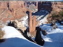
It didn't take long to round the corner and get into the part of the canyon that's more or less hidden from the campground where the trail starts. This is where I slowed down and just enjoyed being out in the cool fall day, a 4.2 mile round trip ahead of me. It's too tiny in this picture to see, but there is actually a patch of snow in the saddle where the shadow is deep all day.

Looking back behind me toward the Visitors Center and highway, I could see how the side of the wash that was protected by the higher peaks to the south and west was very densely vegetated, while the side that took the brunt of the afternoon sun was more desert-like.

This trail splits into 4 different directions after maybe half a mile. Leading to the left (south/southwest) it goes around El Capitan and out on the southernmost rim of the reef. More west/southwest it climbs to Guadalupe Peak, the highest point in Texas. Continuing due west it drops into the wash and follows it to Devil's Hall, and west/northwest it becomes Tejas trail, which is the major east-west trail in the park. A hardy hiker can reach Dog Canyon on Tejas Trail, 12 miles distant by trail, but over 120 by road around the north end of the park, crossing into New Mexico on the way.
I caught some photos of the beautiful fall color on the way, before reaching the bottom of the wash. And was reminded once again that Budd's little digital camera can't do justice to the color. Or maybe it's that my polarized lenses make it look more intense.
I caught some photos of the beautiful fall color on the way, before reaching the bottom of the wash. And was reminded once again that Budd's little digital camera can't do justice to the color. Or maybe it's that my polarized lenses make it look more intense.


Before leaving on this trek, I had dropped by the Visitor's Center for a book that described the trails in detail, and had overheard the ranger telling another couple to continue past Hiker's Staircase to get to Devil's Hall. When I came to this feature, I thought perhaps it was the Hiker's Staircase. After all, it looked like one, especially from the bottom once I had descended.


It turned out that this wasn't the one, nor was the next one on the trail, that I didn't photograph. I might mention here that there were plenty of other hikers on the trail, something I was grateful for, always being mindful that if I do something stupid and break a bone, I'll be dependent on rescue. For that reason, I'm always outfitted to spend the night if necessary, with foul-weather gear, a couple of layers of clothing, two liters of water in my hydration pack, extra high-energy food, and of course my sotol walking stick. I think I look like a dork with all this gear for a short hike, but I mentioned that to the superintendent last week, and he replied quite seriously that for a hike of any length in this area, he always asks himself if he's prepared to spend the night. Because the weather can change in an instant, blowing up over the escarpment with no warning, it's not a bad idea. Most of the other hikers have backpacks, too, so I guess we all look like dorks, and that's ok.
The trail took quite a long way to get to the bottom of the wash, and when it got there the boulders looked forbidding, but by watching carefully where I stepped, I located the path. It soon broadened to what looked like a paved highway by comparison.

Then again there were a couple of places, like this one, where it looked like I had reached a roadblock.

Looking around, I first tried going to the right, but the step up proved too high for my short legs, and there was no good way to use my hands to climb. I put my 4-foot stick against the vertical wall for perspective and backed off to document this problem.

It's hard to see, but the lighter area of smaller rocks and gravel that look like a step--aren't. Take my word for it, this wasn't going to work. Eventually I decided to use the boulder on the left side of the diamond-shaped one the same way I would go around a slick-rock ridge--around the side, using small depressions to place my feet. Coming back I had to laugh, because there was a reasonable trail even further to the left and higher, that I had missed altogether. Let's just say it wasn't well-marked, but it was far easier to descend than to ascend.
The bottom of the wash was very shady, so I didn't take many more pictures until the trail reached what turned out to be two narrow fins in the reef that had been cut through by the wash. From one point, I could see that it opened out into a broader area, almost a hidden canyon. I had come completely around the northeastern escarpment and was behind the bluff you can see from the road.


Passing through between these fins, I finally found Hiker's Staircase.

I had just passed a couple of hikers coming back out, who told me the end of the trail was about 200 yards after you ascend the staircase, which I did using both hands and feet to scramble up. I'm sure younger people with longer legs just go up it like stairs, but I didn't feel stable standing upright, as the strata slope slightly downward, so I abandoned dignity for safety.
It wasn't until I had read more in the book I bought that I realized a narrow slot I passed through was the Devil's Hall formation the trail was named for, so I didn't take a picture from the going-in side. As you come out, this is the vista. The sign says, appropriately, End of Trail. Really?

I found a broad table-like rock from the same stratum as the stairs and set out my picnic lunch, chatting with another party of hikers as they also took advantage of the end of the trail to pause for some rest and food. Since we were departing about the same time, I asked them to go ahead of me so I wouldn't hold them up, and agreed to take a picture of the three of them on their camera. It was then that I noticed the spectacular nature of the Hall, including how the light at the opening reflected from the east wall to the west one, and the tree framed by the opening.


Coming out, I also noticed a feature that I'm used to seeing only in sandstone, instead of the limestone that forms the bluffs and escarpment here. Had to zoom in to make it viewable on a small screen.


I guess there are arches or natural windows almost everywhere if you know where to look for them! As the time was getting away from me and I had to be back for a tutoring shift, I focused on walking faster on the way out and didn't take any more pictures.
I'm feeling stronger and not having to wait so long between hikes any more, so yesterday I ran out to quickly do the nature loop at McKittrick Canyon, which is my next target. Didn't think to take the camera because I was going more for the cardio and just completing it than for the views, but I regret not getting shots of a couple of features that I found interesting.
Tomorrow Budd and I are going into McKittrick Canyon itself. We compromised on the hike, as I wanted to go all the way to the Grotto, which is reportedly an easy hike, if long at just under 7 miles round trip. He's not fond of hiking after all, but is willing to go with me if I'll turn around at Pratt Cabin, making it only a 4 mile round trip. I'll do that with him, and then go back for the longer hike on a weekday.
Speaking of Budd, he just came home for lunch, and here I sit not dressed for the day yet, having been online all morning. Guess I'd better get going!
Subscribe to:
Posts (Atom)