From the outset this hike was weird for me. I planned to do it yesterday, then let the forecast persuade me to put it off until today, which was supposed to be in the low 60s. Then I left late, leaving the house around 11 am. I went first to the Visitor Center to mail a birthday card to a grandson and check their large-scale map for distances, because it shows the distance of each segment of the trail. I wanted to know which end of Frijole trail to approach from, so I could save my legs and my energy for the strenuous part after the Bear Canyon trail turns off. I determined that it was best to start from the trailhead at Frijole Ranch, and then let the interp persuade me to see if I could check out a radio (no), so I think I actually got on the trail about 11:30 a.m., or maybe just a little earlier.
It's been a week of rest and a massage since I wore myself to a nub on Guadalupe Peak trail. You'd think I'd be ready. But even the familiar 1/3 mile from the trailhead seemed to tire me more quickly than it should have. Not to mention the heat! Even on a 55-degree December morning, the sun is HOT at 5500 feet. It was far to the south, so I knew when I turned west there would be shade from the canyon walls, but I was wishing for a short-sleeved T before I got to the first branch of the trail. Still, I pushed on, anticipating a cooler trek once I gained the canyon. Along the way I passed what looked like a shady oasis and thought about eating the trail lunch I had brought--a cheese stick and an apple. But it has become my habit to eat at the turnaround point no matter what time of day that takes me to, so I kept going.
The last time I had hiked this trail I was going in the other direction and I had on new boots. Now those boots have seen more than 30 miles of rough rocky trails--we're old friends. Each time I passed a familiar spot, usually where I had stopped and at least thought about taking a picture, I would think 'The turnoff is just ahead.' I was baking in the sun and really wanted to turn into that canyon where I thought I could stay under the trees in the watershed. Finally, I was right. I spotted the sign for the turnoff just ahead.
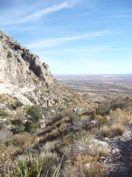
Turning west, I began to feel better about the whole thing. A new trail is always exciting, at least until you discover it wasn't the experience you thought it would be, which I did about a tenth of a mile along, when the trail turned south again and led up to what looked like the top of the ridge! This wasn't the plan...I thought I'd be hiking the watershed. Well, I guess that's either too rough or too ecologically delicate, because the trail skirted the south canyon wall far above it. At least there were times when the steep hillside and the vegetation growing on it afforded a little shade. At one switchback I paused to take a picture back the way I had come.
Looking ahead I saw an area that looked to be deep in the shadow of the mountain, where I decided I would turn around after eating. I knew the Frijole part of the trail was a 3-mile round trip, and that was enough for me. But because my 2 p.m. BodyBugg alarm hadn't sounded yet when I got to the shade, I decided to keep going until either the alarm went off or I reached the end of the shade. Which I did just a few yards further along. At that point, the trail crossed the watershed and continued back to the north side of the canyon, which meant it would be in sun all the way to the top. Nope, I was done.
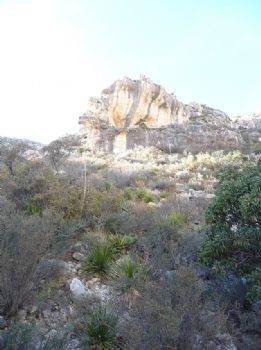
I found a smooth rock and sat down to take off my pack. When I got the cheese out, I found that it had melted to a soggy semblance of its former self, but it was still good. Gobbled it down in three bites, ate my apple, and then got up for the return trip. But not before taking a picture of this outcrop for its interesting color pattern. It was directly above me.
Back I went the way I had come, making better time in spite of picking my steps very carefully. I was almost shuffling, which made my foot get high-centered on a fist-sized rock more than once. The trick is to pick the steps that won't result in a mini rock-slide. No radio, no sprained ankles, that was my plan!
Making it back to the relatively flat part of the trail shortly after two, I couldn't help but compare my condition today with the return trip from Guad Peak. Shoulders, sore from the pack. Knees, sore and stressed from steep downhill climb. Back, pretty tired. What the heck is going on here? The distance, as nearly as I could figure it from the Google tracking application, was a little less than half the Guad Peak distance, at 3.9 miles or so. The time was a little less than half the time, four hours almost exactly when I got back to the car. Why do I feel almost as tired?
I don't have access to a physical trainer or fitness instructor, so I found myself wondering--did I go too soon? Should I have waited a little longer for everything to fully recuperate before taking another steep climb? Or did I go too late, letting my conditioning fall below where I was last week with our long drive to Dallas and no exercise? The question may be moot anyway, as tomorrow and Saturday are the last nice days for at least a week if the 10-day forecast is to be believed. I don't think I could face a challenge that soon. And by the time the wind dies down again (if it does--I can't see beyond the 10 days) it may be too cold or I may be packing to move again.
This could have been my last hike for the year. I may be a little sad about that later, but right now it's ok.
No comments:
Post a Comment